![]()
![]()
![]()
![]()
![]()
![]()
![]()
![]()
![]()
![]()
![]()
![]()
![]()
![]()
![]()
| EXPERIMENTAL
SEISMIC MICROZONING STUDIES FOR CARACAS
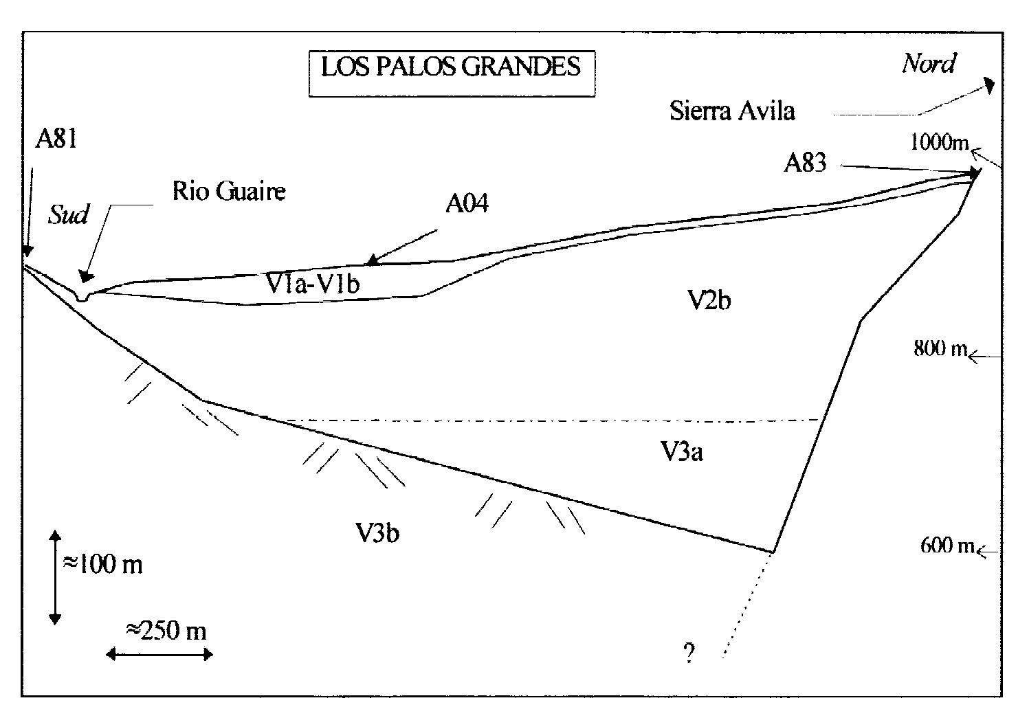
(Investigaciones de microzonificación sísmica por via experimental en Caracas) J.P. Méneroud 1. Introduction During the July 29 1967, Caracas earthquake, numerous buildings were collapsed and damaged in central part of the city, while the magnitude of this earthquake was only 6.4, and the epicenter was situated at more than 56 kilometers. It was quickly obvious, that the importance of damages was linked to the site effects, because Caracas is built on a typical alluvium basin. After the earthquake a very important work was made by American soil specialists and it was clearly demonstrated they had a good correlation between the own frequencies of buildings and the own frequencies of the sites. The Caracas 1967 earthquake was one of the first one where the importance of site effects was demonstrated. For this reason we have tested with the collaboration of FUNVISIS a new method, based on Nakamura technique, that we have developed during the last years. This method called <<H/V microtremors>> applied on down town of Caracas during the months of July and October of 1995. 2. Geological conditions of Caracas The data of geological conditions given here after come from the following studies: Seed (1969), (Weston 1969) and (Whitman 1969). Caracas basin is about 17 Km long, and 4.8 Km wide and it is surrounded by mountains. The Rio Guaire run in the length of this basin, and an important tributary << La sierra del Avila >> meet the Rio Guaire. These rivers have deposed alluvium soils like sand, gravel and hard clay. Numerous studies (seismic refraction, geophysical bore-hole) were made after the 1967 earthquake. The most important zone of alluvium is called << Los Palos Grandes >>. In this area we have direct shear wave velocity measurements, which are given the following results: TABLE 1
On the Table 2 we can see the pressure wave velocity of the Caracas basin soils. TABLE 2
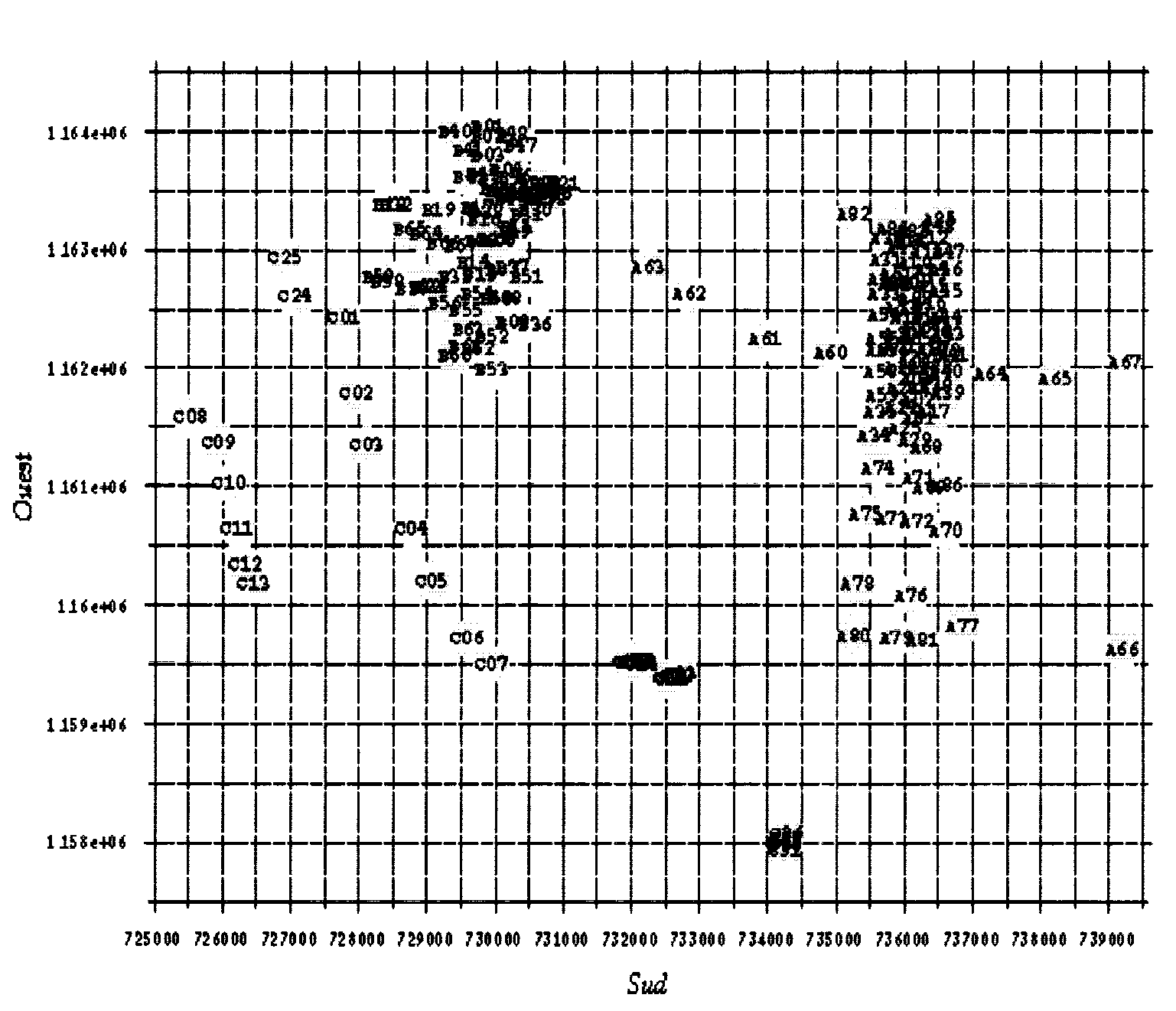
3. Microtremor record operation Only one digital station is normally necessary to record microtremors. Equipment are exactly the same than for earthquake records except that the sensor was not buried. As ground was made of soft fields, we had to place an iron plate under the sensor, in order to improve the contact with soil. Only 4 records in El Este park was realised during the day. The other ones was made during the night between II p.m. and 5 a.m. Some measurements was made both CETE and FUNVISIS material, in order to verify the good accordance between the two appliances. With the logistic support of FUNVISIS two teams are made the records with the help of the police which made secure in the night time. The whole recording system was successively
placed at the 184 points (located on Figure 1) during July and October
1995
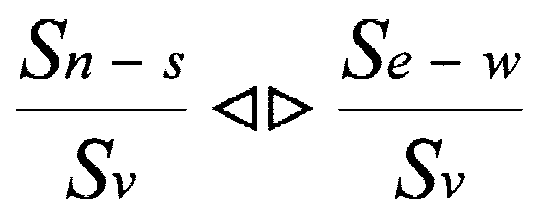
Fig. 1.- Location of the 184 points recorded in Caracas in July and October 1995 At each point, 10 to 15 minutes of "quiet" microtremors were recorded on the three components, with the highest gain. So that the smallest recorded vibration could be of 0.3 nm/s. "Quiet" means that no strong noises, like car or step, disturbed records from less than 10 meters. The sampling rate was 125 Hertz. 4. Principle of H/V method The method used in this study was initially proposed by M. Nogoshi and T. Igarashi, this method was going over again and applied by Nakamura in urbanised area of Japan. Spectral ratio between horizontal and vertical component (H/V) bring to the force resonance frequency of the site. We will call one of the two following formulae:
Where S is the mean spectrum n-s, the north-south component e-w the cast-west component and v, vertical one.
Fig. 2.- Illustration of Nakamura
theory of the H/V method. Ss surface signal spectrum; SB basis
alluvium spectrum; H horizontal spectrum; V vertical spectrum.
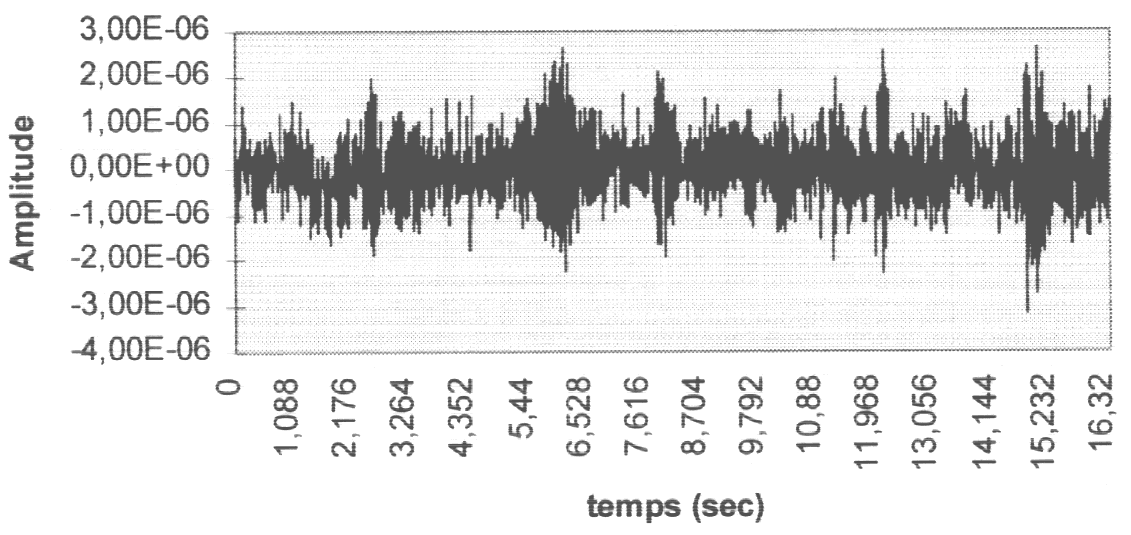
For each studied site the ratio between horizontal component spectrum and vertical one are drawn this ratio give the transfer function of the site. 5. H/V ratio for each site Processing: For each microtremor record, 5 windows
of 16 seconds duration were selected among the most quiet part of signal.
A 30% taper window is applied to these data. Then an amplitude spectrum
is computed over 2048 points and smoothed. For each track, 5 spectra are
available, from which an average spectrum is performed: the north-south
or east-west mean spectrum of a site is called H, the vertical one is called
V. The horizontal over Vertical spectral ratio (H/V) from microtremor is
performed and plotted versus frequency for each site.
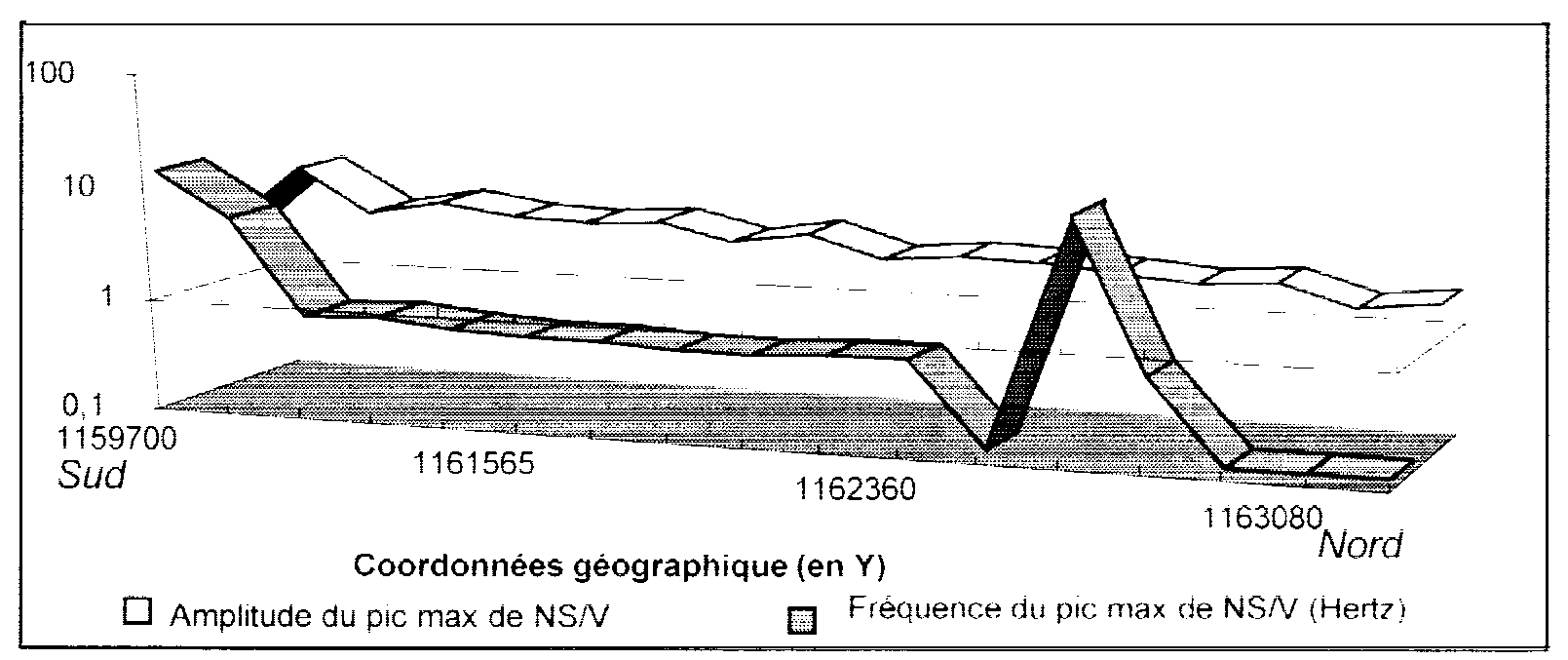
Comments on results: H/V ratios were performed for the 184 investigated sites. The first fact that has to be pointed out is that the behavior of H/V curves is strongly related to the nature of the soil where measurement was performed, and in accordance with the damages observed after the earthquake. For instance on the Palos Grandes site where damages and collapses of buildings was maximal this method has given very good results We can observe on the two following figures (4, 5) that the frequency is minimal in the central part of the basin. On the other hand this frequency is most important in the south, where it increases with a progressive way, and in the northern part where it increase very quickly. This results are in total accordance with the deep and the profile of the basin and the geotechnical data. We can observe on the Figure 4 that the substratum climb is more gentle in the south than in the north where it is steep.
Fig. 5.- H/V results for the Los Palos Grandes profile From the results on the Palos grandes zone
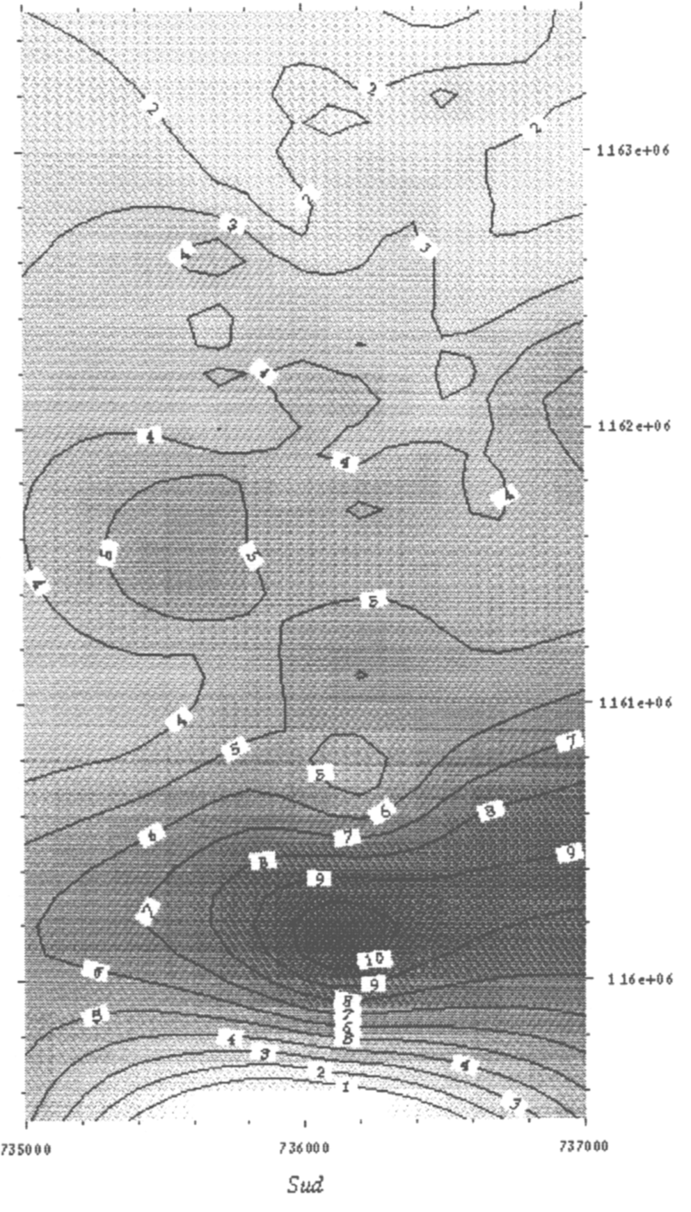
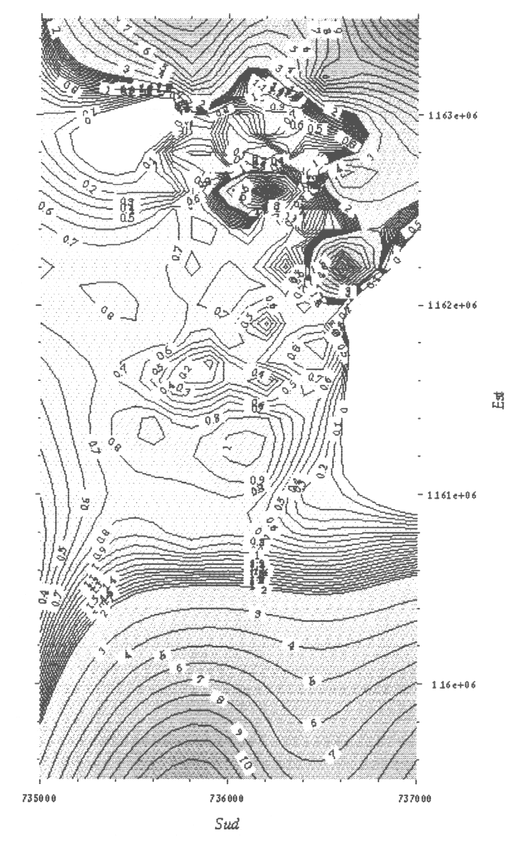
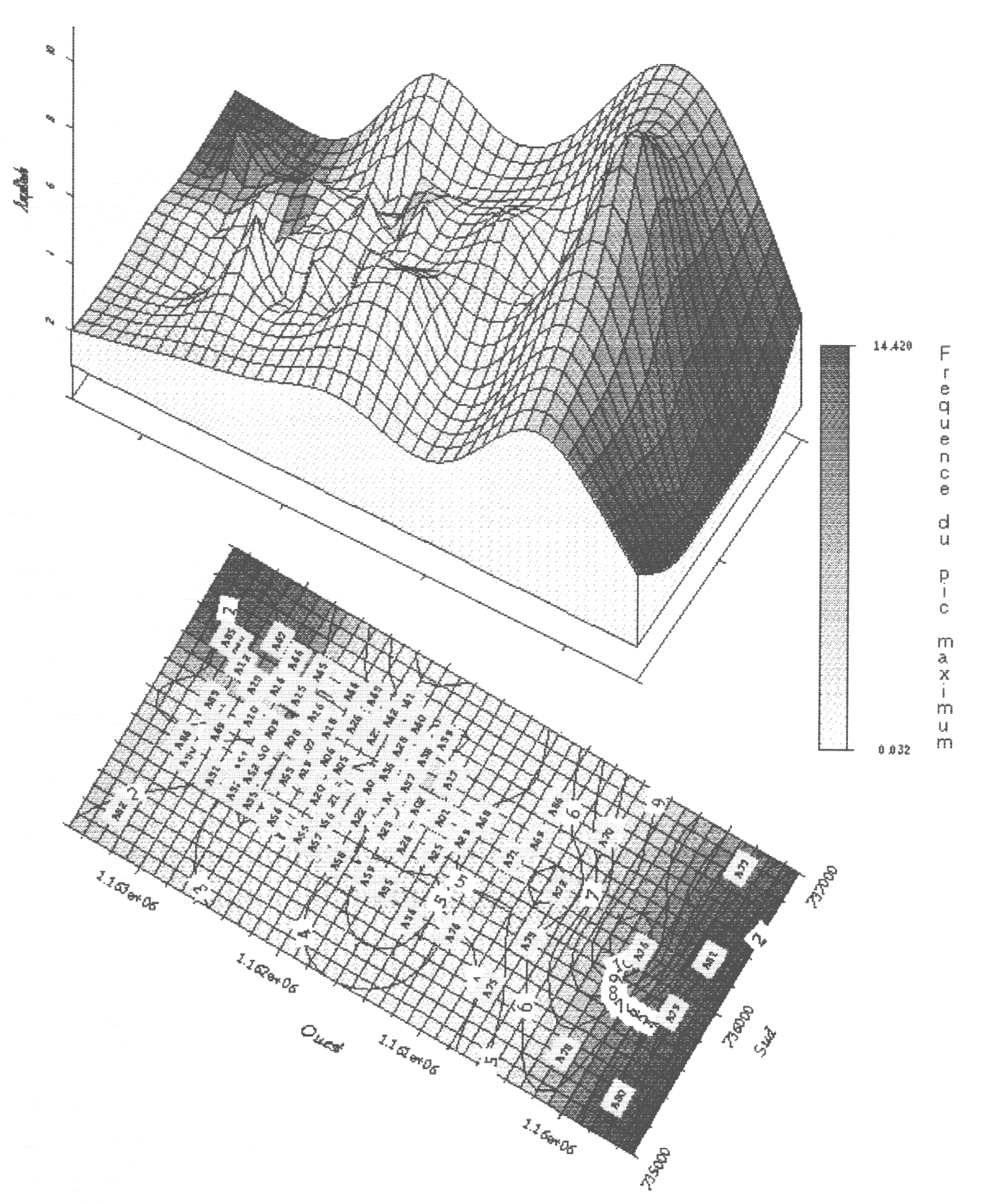
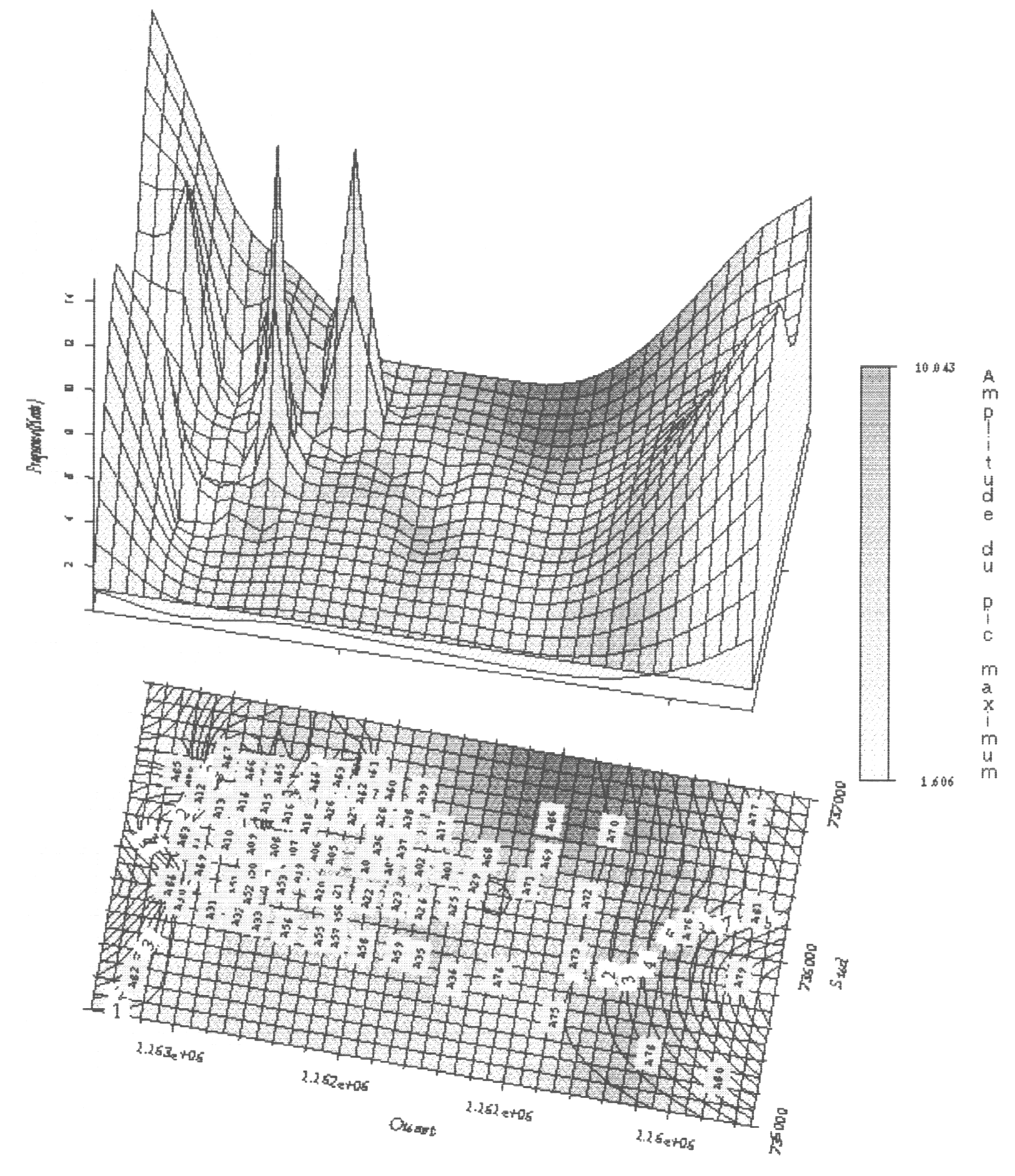
we have drawn two map (fig 6 and 7): the first one gives the equal amplitude
curves and the second one gives the equal frequency curves. These maps
render not only the seismic response of the site but also the shape aspect
of the Palos Grandes basin and in particular the deep of alluvium-substratum
contact.
The two figures given hereafter (8 an 9) show another possibility to give information about the results of this experimentation.
6. Conclusions Microtremor measurements are very easily, quickly and economically done. This technique allows to investigate seismic response of very numerous sites. Each curve seams more or less consistent with expected transfer function of the studied site. It seams interesting to verify results overall by means of interpolations. Two data types were studied in H/N curves: frequency where maximum amplitude occurs on one side, and the amplitude itself, on the other side. These computations can be performed inside different frequency bands with a interpolation step of 20 meters. For instance it is possible to observe on which place the seismic response is the more sensible to a given frequency of the signal, in other words, where the signal should be amplified at this frequency. This technique has given a good results
on Caracas sites in accordance with the studies made after the 1967 earthquake,
and confirm the seismic amplification given by Caracas basin at low frequency.
|