![]()
![]()
![]()
![]()
![]()
![]()
![]()
![]()
![]()
![]()
![]()
![]()
![]()
![]()
![]()
![]()
![]()
![]()
| ESTIMATING
POTENTIAL EARTHQUAKE LOSSES IN MODERN CARACAS
ROBERT V. WHITMAN
ABSTRACT A new-generation methodology for estimating potential losses during future earthquakes has recently been developed, intended for use by local governments in planning steps to mitigate an earthquake problem. The methodology, which permits study of a broad range of constructed facilities and estimation of various types of losses, uses peak ground acceleration or velocity and spectral response as input-rather than Modified Mercalli Intensity as typically employed by earlier procedures. Software (HAZUS) has been written to implement the new methodology. While HAZUS as currently written applies directly only to cities within the United States, it can be used to provide at least preliminary results for cities elsewhere. Such a crude preliminary study has been made for Caracas. This study first benchmarks HAZUS's predictions against experience with concrete buildings during the 1967 Caracas Earthquake, and then analyses the potential benefits achieved by improvements in seismic construction since 1967. INTRODUCTION I very much regret that an unexpected heath problem has prevented me from participating in this Seminar commemorating the 1967 Caracas Earthquake. Attendees at the Seminar already know well the important influence of that earthquake upon the practice of earthquake engineering, not only in Venezuela but throughout the world. Building code requirements for concrete structures underwent major changes as a result of the unfortunate collapse of multi-story structures. I was fortunate to be invited, along with Prof. H. Bolton Seed, to assist in developing an understanding for the concentration of severe damage in the Los Palos Grandes portion of the city. This study influenced international thinking concerning the effect of local soil conditions upon earthquake ground motions. My focus in this paper is upon estimating potential losses during future earthquakes. I have chosen this topic for several reasons. First, there currently is great interest in the United States concerning loss estimation, with much new research and development. Second, an excellent data base was compiled concerning the extent of damage in the 1967 Caracas Earthquake. This provides an opportunity to "benchmark" new loss estimation methodologies. Lastly, it is interesting to use a loss estimation methodology to explore the relationship between building practice in Caracas and the potential for losses during future earthquakes. ESTIMATING LOSSES FROM FUTURE EARTHQUAKES The first earthquake loss estimates in the United States were carried out in the 1970s, with the primary purposes of stimulating concern about future losses and of helping to plan emergency response. The general approach was to use Modified Mercalli Intensity (MMI) to characterize the ground shaking caused by a selected earthquake, together with empirical relations between MMI and building damage loss and casualties. These latter relationships came from data compiled by insurance companies, and were largely limited to small-to-modest sized residential buildings. As interest in loss estimates expanded, MMI-to-damage relationships for a wider variety of structures and for lifelines were developed on the basis of expert judgement (Applied Technology Council, 1985). A report prepared by the National Research Council (1989) provided a comprehensive review of available methodologies plus thoughts concerning achievable accuracies and applications. The insurance industry continued to have a major interest in loss estimation, which accelerated following the large and costly earthquakes in California in 1989 and 1994. That industry has supported development of several proprietary loss estimation methodologies, and has stimulated the entry of a number of commercial companies to develop methodologies of their own. There has also been recent interest in methodologies for estimating losses to lifelines. THE FEMA/NIBS LOSS ESTIMATION METHODOLOGY At the end of 1992, the Federal Emergency Management Agency (FEMA) initiated a major effort to develop a new-generation loss estimation methodology. The aim has been to develop a comprehensive tool for use by state, regional and local governments in assessing the threat of losses from earthquakes, in planning and preparing for disaster response and recovery, and in developing plans and actions that will reduce potential earthquake-related losses. FEMA is especially interested in the last of these purposes - under the general name of mitigation. The National Institute of Building Sciences (NIBS) was given the task of organizing and administering the effort to develop the new methodology. Several groups of experienced experts were assembled to provide overall direction and leadership. The actual work of assembling the required algorithms and parameters, and of implementing the methodology into software, was carried out under contract by Risk Management Solutions (RMS) of Menlo Park California. The FEMA/NIBS methodology is characterized by:
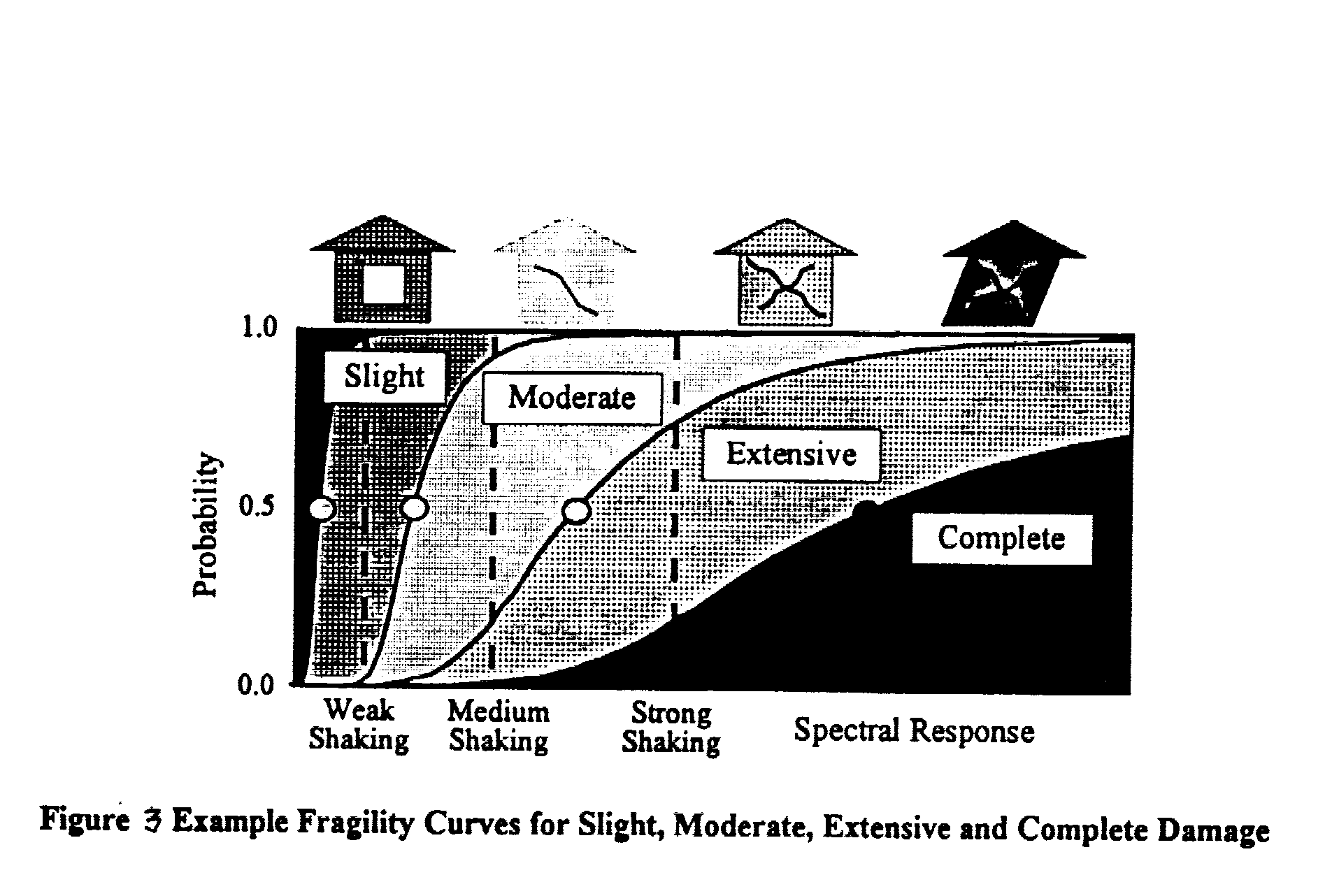
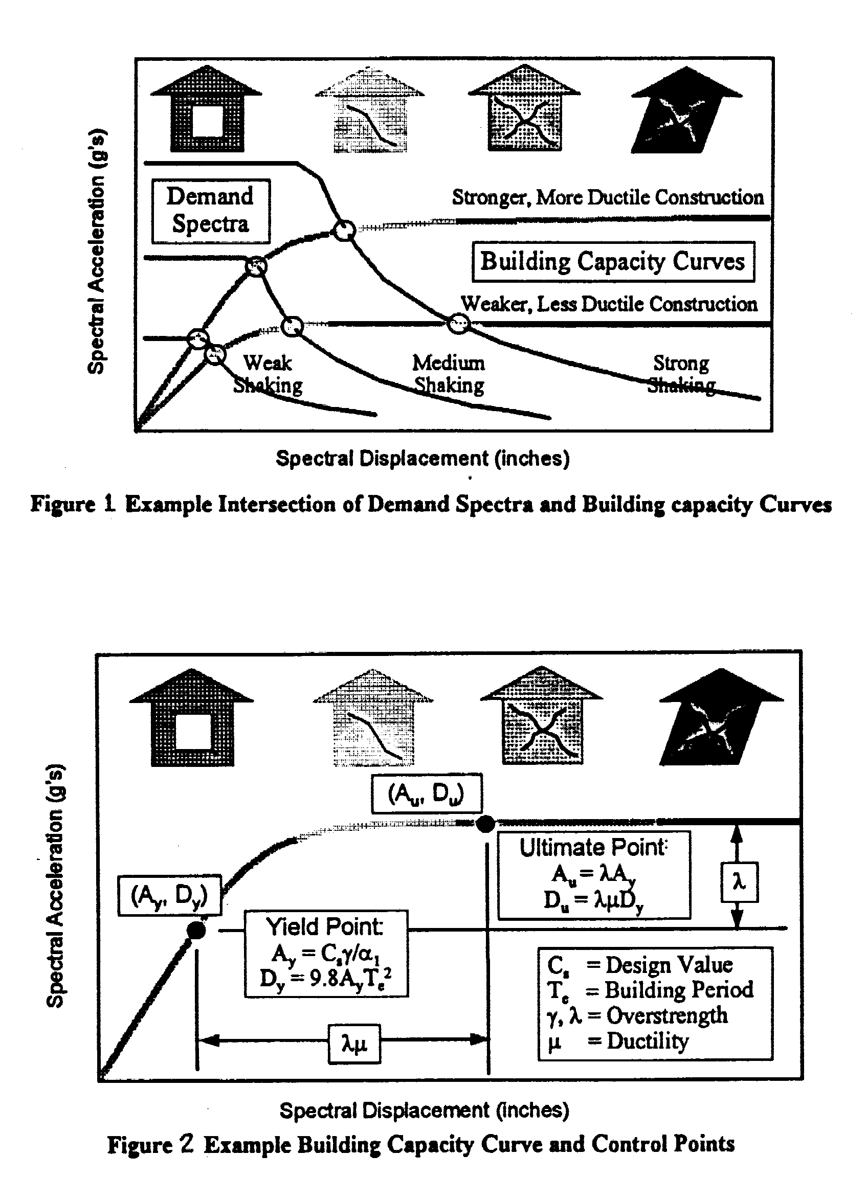
The software comes with extensive data bases with default values for inventory of constructed facilities, and for demographic and economic data. Use of this default information makes possible preliminary and simple, approximate analyses. An analysis using HAZUS begins with identification of the study area. The basic geographic unit is a census tract - selected because of the data that can readily be associated with each census tract. The user of HAZUS typically selects one or more counties, or portions of counties, to define the area - and HAZUS then generates a listing of all census tracts within the study area. The next step is specification of an earthquake of interest - providing a magnitude, an epicentral location, a focal depth, and information concerning the nature of the fault. HAZUS then computes the ground motions, for a reference site condition, for all points within the study area. The user may input into HAZUS maps that describe the geographic distribution of soil types, and HAZUS corrects the ground motions accordingly. Maps for liquefaction and landsliding hazards may also be entered into HAZUS. A major step is preparation of the inventory of constructed facilities within the region, by supplementing and correcting the default data bases. The methodology comes with guidance in the carrying-out of this task, which can involve a considerable amount of coding after the pertinent data have been assembled. At this point, a user makes a number of choices concerning the form of output from the calculations, and the computer takes over. Damage to buildings and lifelines is evaluated in terms of damage states, and HAZUS then relates various economic and social losses to the damage states. Losses can be aggregated across all building and occupancy types, by census tract or by groups of census tracts, and for various lifeline systems. ESTIMATING DAMAGE TO GENERAL BUILDING STOCK The balance of this paper focuses upon the general building stock, which includes residential, commercial, industrial, agricultural, religious, governmental and educational buildings. The methodology does not predict losses for individual buildings. Rather, all buildings of a given type within some small geographic area are "lumped" together, and the methodology estimates the fractions of these buildings experiencing different levels of damage. Classification of buildings. Building structures are classified into 36 model building types, distinguished by the material and type of framing and by the height of the building. Examples of building types are: steel braced frame, concrete shear walls, concrete frame with unreinforced masonry walls and unreinforced masonry bearing walls. As regards height, buildings are classified as low-rise (1-3 stories), mid -rise (4-7 stories) and high-rise (8 or more stories, with a typical height of 12 or 13 stories). Buildings can be further classified according to seismic resistance. "Pre-code" buildings are those not specifically designed against earthquakes. Three levels of design according to codes are recognized: "High-code", "moderate-code", and "low-code" - corresponding roughly to design requirements for zones 4, 3 and 2 in the United States. Evaluation of damage, Briefly, the calculations proceed as follows:
Extensive: Some frame elements reach ultimate capacity or suffer shear or bond failure. This damage state is life-threatening. Moderate: Some frame elements reach yield capacity. Slight: Flexural or shear hairline cracks. None: "PREDICTING" DAMAGE CAUSED BY 1967 CARACAS EARTHQUAKE Considerable information concerning the inventory of buildings and lifelines, and also concerning building usage and demographics, is necessary for calculation of the aforementioned losses. HAZUS contains default information for cities in the United States, which permits useful, preliminary loss estimates to be made for these cities. In its present form the full power of HAZUS cannot be applied to cities outside the United States. However, with some imagination it is possible to do some simple analyses that are at least approximately applicable to Caracas. One form of output information from HAZUS is the probability that a particular model building type will experience the various damage states, given a specified shaking. In particular, it seems appropriate to evaluate damage probability for buildings with concrete moment-resisting frames - a common form of construction in Caracas in 19672. In the data base compiled by the Presidential Commission following the earthquake, damage information was tabulated for 4 groupings of buildings according to height: 5-9 stories, 10-14 stories, 15-20 stories, and 20+ stories. There were very few buildings in the last category. The first two groupings correspond roughly to two of the height categories in HAZUS: high-rise: 8+ stories, with 12-13 stories typical The 1967 damage data base distinguishes between buildings located in Los Palos Grandes and elsewhere in the city. In Los Palos Grandes, both damaged and undamaged buildings were counted. Elsewhere in the city, there was a count of all damaged buildings, but the total number of buildings was estimated. The following table gives the percentage of buildings with at least slight structural damage: Stories Los Palos Grandes Elsewhere 5-9 8% 7% >9 42% 4% (10-14) (31%) (4%) (>14) (78%) (4%) Note that the >9 stories category has been broken down further by height, so as to emphasize the trend for damage to increase with height in Los Palos Grandes. There were three total collapses of buildings located in Los Palos Grandes, plus several buildings that suffered extensive damage. No collapses occurred elsewhere in the city. In order to employ HAZUS to estimate damage in Caracas, a small number of census tracts were selected from a city located in California. The inappropriate information concerning building inventory, etc. that came with this choice of census tracts could be ignored as long as one focuses only upon predicted damage ratios for a specific building type. It was assumed that the seismic resistance of these structures could be classed as "pre-code". An earthquake with magnitude 6.3 was placed approximately 60 Km away, and was assumed to result from strike-slip faulting. HAZUS rates site conditions using the average shear wave velocity within the topmost 100 ft. (30 m) of earth. Based upon in-situ measurements made following the 1967 earthquake, the shear wave velocity throughout the alluvial valley occupied by Caracas is about 750 ft/sec for the first 20 m, followed by a considerable depth at 1500 m/sec. Hence the average velocity for the top 100 feet is 1000 m/sec. This value fits soil site category D in HAZUS, which happens to be the default site classification for the methodology. Based upon these assumptions, HAZUS computes the following damage ratios for moment-resisting frames. Damage State Height At least slight Extensive Complete Mid-rise 7% 0% 0% High-rise 14% 1% 0% For mid-rise buildings, these predictions are generally consistent with observations in 1967. Moving to high-rise buildings, the trend is in the wrong direction and the numbers are too high. Likely this is the result of assuming that all buildings were "pre-code"- undoubtedly the design standards were better for at least many of the taller buildings3. None the less, considering all the assumptions it can be said that HAZUS provides reasonable estimates for the damage in 1967 for parts of Caracas other than Los Palos Grandes, and for mid-rise buildings in Los Palos Grandes. According to the soil classification system in HAZUS (which is the same as that in the new 1997 recommendations from the Building Seismic Safety Council in the United States), site classification D would apply to Los Palos Grandes - since no attention is paid to a depth of soil greater than 100 ft. Clearly HAZUS fails badly in estimating damage ratios for high-rise buildings; the percentage experiencing at least slight structural damage is badly underestimated, as is the number with complete damage and collapse. Several possible explanations can be offered for this discrepancy. Perhaps HAZUS's pushover and/or fragility curves for high-rise moment-resisting frames do not properly account for the behavior of very tall buildings. However, if the curves were to be adjusted to predict more damage, the estimated damage in areas other than Los Palos Grandes would be even further over-predicted. Another explanation, more consistent with conclusions reached immediately following the earthquake, is that actual ground motions in Los Palos Grandes were more severe in the period range of importance for tall buildings - than in the rest of the city. Various assumptions were made in using HAZUS to see whether observed damage in Los Palos Grandes could be predicted in a credible manner. First, it was assumed that site classification E might apply. In HAZUS's site classification system, site category E denotes a soft soil - typically clay. Clearly the soil in Los Palos Grandes was not soft in this sense, but this assumption is one means for having HAZUS predict stronger long-period ground motions. Then the magnitude of the assumed earthquake was increased in small increments. The following table summarizes the results, all for high -rise buildings. Damage State Mag. Site (Sa)1 At least slight Extensive Complete 6.3 D 0.059g 14% 1% 0% E 0.086g 29% 3% 0% 6.6 E 0.120g 49% 6% 1% 6.7 E 0.139g 56% 7% 2% In examining this table, keep in mind that something like 42% of the high-rise buildings in Los Palos Grandes were observed to have at least slight structural damage and that about 3% collapsed with perhaps 2 or 3 times that marry suffering at least extensive damage. The damage pattern computed using M=6.6 and E site conditions bear a similarity to the observed conditions, except that the number of collapses is underestimated. It is of particular interest to review the theoretical studies made following the 1967 earthquake concerning the effect upon ground motions of the very great depth of soil underlying Los Palos Grandes. Response spectra computed by Whitman (1969) and Seed et al. (1972) show peaks in the range of 1.0 to 1.5 sec. If a smoothed spectra is to provide a reasonable match to the computed ordinates over this range of periods, the (Sa)1.0 ordinate must be about 0.12g. Thus there is reasonable basis for using ground motions computed with M=6.6 and E site conditions to simulate the seismic environment for high-rise buildings in Los Palos Grandes. As formulated at present, HAZUS is not equipped to deal with site conditions that cause predominant response spectral peaks at long periods. However, it appears that HAZUS can reasonably well predict damage ratios for moment-resisting concrete buildings when appropriate ground motions are used - except that the number of collapses may be underestimated. POTENTIAL DAMAGE IN CARACAS DURING FUTURE EARTHQUAKES Having established that HAZUS, if used appropriately, can provide reasonable estimates concerning the damage caused to concrete buildings in Caracas in 1967, it is useful to explore the potential benefits of having improved quality of construction. For this purpose, a series of runs were made varying the assumed design level for concrete buildings. Examination of first results revealed that imposition of "moderate-code" and "high-code" requirements does not improve the performance of moment-resisting frames significantly (at least according to HAZUS). Hence it was assumed that buildings designed for these levels of code requirements would employ shear walls to resist lateral forces. An earthquake somewhat larger than the 1967 event was assumed: a magnitude 7.0 earthquake with an epicenter 60 Km distant from the city. The results appear in the following table; the site condition is D everywhere. These results for mid-rise buildings should apply throughout the city, and for high-rise buildings elsewhere than Los Palos Grandes Damage State Design level Height At least slight Extensive Complete Pre-code Mid-rise 37% 2% 0% Low-code Mid-rise 23% 1% 0% Mod. Mid-rise 16% 0% 0% High-code Mid-rise 13% 0% 0% Pre-code High-rise 52% 6% 1% Low-code High-rise 37% 3% 0% Mod.-code High-rise 31% 0% 0% High-code High-rise 28% 0% 0% In order to simulate the unusual ground motions expected in the Los Palos Grandes area, a magnitude 7.3 quake was assumed together with HAZUS's amplification factors for E site conditions. The estimated damage ratios then become: Damage State Design level Height At least slight Extensive Complete Pre-code Mid-rise 92% 24% 10% Low-code Mid-rise 76% 12% 3% Mod.-code Mid-rise 56% 1% 0% High-code Mid-rise 41% 0% 0% Pre-code High-rise 98% 33% 20% Low-code High-rise 89% 20% 7% Mod.-code High-rise 72% 2% 0% High-code High-rise 70% 1% 0% It is seen that, without the benefits of a high level of design requirements, devastating damage must be expected in Los Palos Grandes and life-threatening damage elsewhere. The results also emphasize that the primary benefit of high level design code requirements is to protect life safety; costly damage generally still can occur during a very strong shaking. HAZUS also allows for buildings with "superior" seismic resistance, which implies buildings in which special measures, beyond those required for life safety, have been taken to reduce potentially costly damage. However, the expected benefits from requiring such measures have not be examined in this preliminary study. FINAL REMARKS Benchmarking HAZUS against the experience of the 1967 Caracas Earthquake has provided modest support for the ability of HAZUS to estimate damage to concrete structures - provided that the possible existence of unusual ground motions is taken into account. There is some indication, however, that the potential for complete collapse of inadequately designed moment-resisting frame buildings is underestimated by HAZUS. Using HAZUS to explore the potential for damage during earthquakes larger than that in 1967 has emphasized the importance of stringent design requirements to protect life safety, and further suggests that even better designs may be warranted to reduce the likelihood of costly damage. Even though HAZUS is not now set-up for easy application in cities outside the United States, it is possible to apply HAZUS to places such as Caracas. A set of census tracts must be selected from some city in the United States, covering approximately the geographic area of city to be studied. A representative soil type may be assigned to each census tract. The various data bases embedded in HAZUS square footage of different types of occupancy, distribution of buildings according to model building type, population, economic data, etc - can be replaced by data appropriate for the studied city. Similarly, locally available information concerning lifelines may be introduced. While considerable effort would be required to assemble this information and to code it into the software, much can be learned by taking one step at a time. In this manner, the very preliminary results presented in this paper may be improved, and used as a basis for decisions concerning measures most suitable for mitigating the potential losses from future earthquakes that inevitably will impact Caracas. REFERENCES National Research Council, 1989: Estimating Losses from Future Earthquakes, available as FEMA-177, Federal Emergency Management Agency, Washington DC. Seed, H.B., R.V. Whitman, H. Dezfulian, R. Dobry and I.M. ldriss, 1972: Soil Conditions and Building Damage In 1967 Caracas Earthquake, J. Soil Mech. and Found. Eng, ASCE, Vol. 98, No. SM8, pp 787-806. Whitman, R.V., 1969: Efecto de las condiciories del suelo en el daño producido a las estructuras por el Terremoto de Caracas del 29 de Julio de 1967; Estudio realizado para la Comision Presidencial. Whitman, R.V., T. Anagnos, C.K. Kircher,
H. Lagorio, R.S. Lawson and P. Schneider, 1997: Development of a National
Earthquake Loss Estimation Methodology, submitted for publication in SPECTRA,
Earthquake Engineering Research Institute, Oakland CA.
|